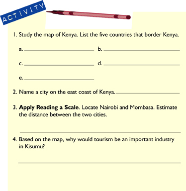
Looking At KENYA
Where in the World Is Kenya?, What Is the Geography of Kenya?
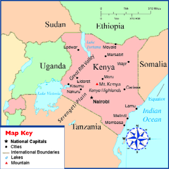
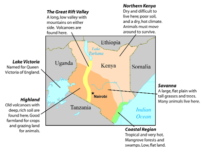
Kenya is on the east coast of Africa. On the map, find the equator. It runs through the middle of the country. The equator explains the climate. Coastal areas have a tropical climate. The region has a lot of rain and is very hot. In the north and east, the land is arid, or very dry. Kenya shares borders with Somalia, Ethiopia, Sudan, Uganda, and Tanzania. The Indian Ocean lies along the east coast.
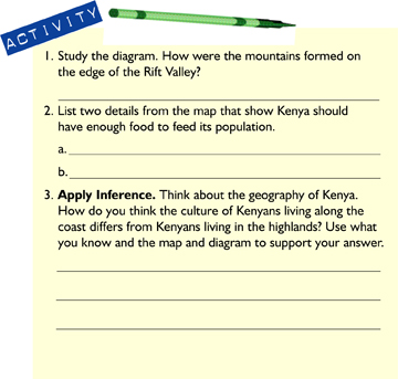
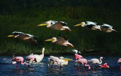
Kenya is 224,961 square miles (582,650 sq. km.). It is about twice the size of Nevada. Tourism is important for the economy. Tourists can go on a beach safari to visit coral reefs and mangrove forests. A mangrove forest has trees and shrubs that can live in salty water along a coast. Visitors can also go on safari on the Serengeti Plain. They will see thousands of different birds and wild animals.

Is Kenya an unknown land to you? Do you wonder what life is like for people sharing the land with wild animals? Perhaps you know that a Kenyan plays basketball on an American team. Have you watched marathon, or long-distance, runners from Kenya race in the United States? With your classmates, make a list of all the things you would like to know about Kenya.
 Political Map of Kenya
In the center of Kenya, there are highlands. Find the Kenya Highlands on the map. The Kenya Highlands have very rich soil. It is one of the most successful farming regions in Africa.
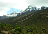 Mt. Kenya is 17,058 feet high. It is the second highest mountain in Africa. The highest is Mt. Kilimanjaro in northeastern Tanzania—19,340 feet.
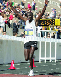 James Saina of Kenya wins the 2005 Athens Classic Marathon.

Kenyan male runners have won 15 out of 20 of the Boston Marathons. Kenyan female runners have won the past 5 out of 7. Kenyan athletes have also won several Olympic medals. No one is sure why Kenyan runners are so good at their sport. Some guess that because the runners train at high elevations, they have increased strength and endurance.

The scale on a map helps you understand distance. It tells you how far places are from each other. The marks measure distance in miles and kilometers. For example, if you needed to travel along the length of Kenya's coastline, about how many miles would that be? Look at the scale. The coast is about 333 miles (536 km) long.
![]()
Kenya is on the east coast of Africa. Kenya has a mix of climates. The equator runs through the center of the country. That area has a tropical climate. To the north and east, the climate is arid.
 Physical Map of Kenya
What Is the Geography of Kenya?
Let's start to explore Kenya at the coast. Look at the map. Notice that the coast has low, flat land. It has an area where the grass and soil are full of water. These areas are swamps. The coast also has white sandy beaches and light blue seas.
As you travel inland, the land rises into a higher flat plain, or savanna. The savanna has special grasses and trees. Animals live together in groups, or herds.
In the north, it is so dry that the people are nomads. They move with their animals to find better grazing land.
Lake Victoria is the largest lake in Africa. It is the source of the Nile River. The lake is very shallow. In some places, the water is only 40 feet (12 m) deep. The other large lake in northern Kenya is Lake Turkana. The area around the lake is hot and very dry.
One amazing feature is the Great Rift Valley. A rift is a separation in the earth's crust. The valley runs north and south through Kenya. Part of the land in East Africa and the Arabian Peninsula are pulling away from each other. The movement causes large cracks in the earth's surface. The land in between drops down to make a valley. Bubbling below the land is red-hot liquid rock called magma. When magma explodes through a hole in the earth, it makes a volcano. Mount Kenya is an old volcano. Over millions of years, wind and rain wear volcanoes down into rich soil.
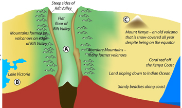 Diagram of Physical Features in Kenya
West
East
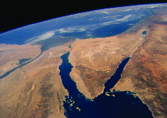 A. Northern section of the Great Rift Valley as seen from space
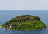 B. A small island on Lake Victoria
 C. Mount Kenya

When an author does not give you enough facts to draw a conclusion, you must make an inference instead. To make an inference, use the facts you are given, your knowledge, and your common sense. For example, You smell smoke. You can infer that something is burning.
![]()
The Kenya Highlands have some of the best soil in Africa. Large areas of open grassland are very near the coast. The Great Rift Valley is caused by the land in East Africa and the Arabian Peninsula pulling away from each other. Volcanoes in the valley make rich farmland.
What Is the Climate Like in Kenya?

Mount Kenya sits right at the equator. At the bottom of the mountain, the temperature is higher. But at the top, the temperature is so low that there is snow all year.
Climate is affected by distance from the equator and differences in elevation. Kenya is located on the equator. The sun is directly overhead. This means that Kenya has a lot of sunshine and high temperatures. Most of the country is hot and dry. But there are some differences.
The coastal areas are hot and humid all year. Humid means the air holds a lot of water. It rains often along the coast. Winds from the ocean sometimes lower the temperature.
The lowlands are further away from the equator. They are hot but drier. They do not get as much rain. Droughts are common. They cause serious problems. When crops and grasses for animals die, people do not have enough food. People can starve. The mountains and plateaus in the north have a highland climate. The climate is cooler. It is mild and good for farming. There is enough rainfall. Most of the population lives in the highlands.
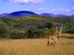
Most parts of Kenya get some rainfall during the year. The coast and eastern plateaus have two rainy seasons. There is a ‘long rainy season” from March to June. After the rainfall, herds of wildebeest cross the border from the Serengeti National Park in Tanzania. They travel north to the Masai Mara National Park in Kenya. Almost two million animals are on the move! They must cross a river filled with hungry crocodiles to reach the Mara grasslands.
 Mountainous region in southern Kenya
This is the only area that has enough food for them. This annual migration is popular with tourists and filmmakers. In November, during the “short rain season” from about October to early December, the wildebeest return to their lands in Tanzania.
 Wildebeest on the Serengeti
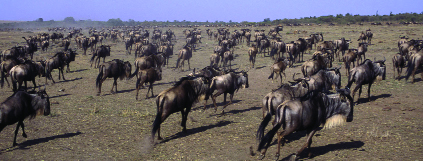
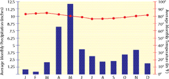
 Climograph: Nairobi, Kenya
 Climograph: Mombasa, Kenya

Remember that a climograph shows the average monthly temperature and average monthly precipitation. It helps you understand the climate of an area. The lines show temperature. The bars show rainfall. Study the climographs of two cities. They will help you compare and contrast to see how the climate is alike and different in two areas of Kenya.
![]()
Most of Kenya has a hot, dry climate. The equator cuts through the middle of the country. Along the coast, in areas like Mombasa, the climate is tropical. There are swamps and forests. The plateaus and grasslands are dry and hot. There is less rainfall away from the equator. The mountains have a mild, highland climate. The temperature is cooler, and the area is drier. The climate is good for farming.
How Do Kenyans Use the Land?
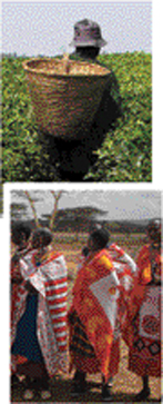 Worker on a tea plantation
Masai people
Agriculture is the main industry in Kenya. About 75 percent of the people are subsistence farmers. They grow just enough food for their families. There is very little food left over for sale. Look at the land use map. Find the areas in yellow. These areas in the highlands have good farmland. There is a heavy rain almost every afternoon. The climate is cooler. Most of the farms are very small. Most families in this region have at least six children. Large families need a lot of food. Around each farmhouse is a small garden called a shamba. Most shambas grow maize (corn), beans, yams, and tropical fruit, such as bananas. The climate and soil allows farmers to grow two crops a year. They raise chickens and keep one or two cows.
If there is extra food, people sell it at outdoor markets. The markets are open in the morning. By noon, it is so hot that everyone goes home. At the end of the afternoon, people work in their shamba or gather wood for cooking stoves.
Now find the plantation areas on the map. European settlers also liked the cool, wet climate of the highlands. When they arrived in the region, there were thick forests. Settlers cleared the land. Then they planted tea bushes. Tea is grown on huge farms called plantations. Tea is a cash crop. A cash crop is one that is grown for export. Tea is Kenya's most valuable export.
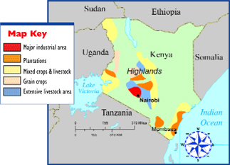 Land Use Map of Kenya
There are many tea plantations in the region. The bushes are planted in long rows. The leaves are picked by hand and not machines. This means that the collection of tea takes a lot of labor. The pickers work nine hours a day. They and their families are given a place to live, education, and health care. One plantation can have as many as 16,000 workers. Each tea plantation has its own schools, a hospital, and stores. The houses have electricity, water, and sewers. Each picker earns about fifty cents a day.
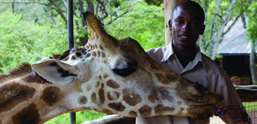 A ranger with a giraffe at the giraffe center in Nairobi, Kenya
South of Nairobi are the lands of the Masai (mah-seye). The Masai are nomads. They have herds of cattle and goats. During the long dry season, they move their herds to find grass and water. The Masai use these animals for food. Recently, the way of life for the Masai is changing. Some grazing land has been planted with crops. Some land has been taken by the government to make national parks. Droughts have hurt grass and water supplies. Some of the land is used for modern cities like Nairobi. The growth of cities has taken away grazing land. It is now difficult for the Masai to move around with their cattle. Many people now live in small towns.
Tourism is the largest industry in Kenya. In 2005, Kenya received about 552 million dollars. About 1.6 million people visited the country. Although Kenya is a poor country, it is rich in magnificent places to visit. The coast has beautiful beaches. Hotels and stores serve tourists. They also supply many jobs for Kenyans.
Kenya has over 50 national parks and animal reserves. About 10 percent of the land in Kenya is protected by national parks. The parks were made for tourists and to protect wildlife. Tourists pay to visit the parks. When the government set up the parks, some tribal groups were moved off their lands. A tribal group is made up of families that share the same culture and language. The tribes cannot live in the parks.

Supporting details are important because they give meaning to the main idea. They help you remember the main idea by giving you examples. The way of life for the Masai is changing. (main idea) Droughts took away grass and water. They can't graze their herds in the national parks. (supporting details)
![]()
Most people in Kenya live on small farms. They are subsistence farmers. They have few crops to sell at the markets. Large tea plantations are located in the highlands. Tea is a valuable export crop. Some tribal herders on the grasslands are losing their land. The national parks and growth of cities are taking grazing land.
How Has History Shaped the People of Kenya?
Geography and climate are important in the history of Kenya. The rich highland soil, thick grasslands, and safe coastline brought many people and cultures to the region.
Beginning about 500 B.C., Bantu-speaking people arrived in the region. They came from the west. The Bantu left their homes because the land was too crowded, and the climate was getting drier. They came in small groups. The groups settled peacefully throughout the region. They brought iron tools. These tools helped plow the land and cut down forests. The Bantu migration lasted about a thousand years. About 75 percent of the people in Kenya today are related to these Bantu-speaking people.
About A.D. 700, Arab traders began to sail dhows between the Persian Gulf and East Africa. A dhow is an Arab ship that carries trade goods, food, or timber. The Arabs built towns along the coast. Some early traders came from Indonesia. Later, traders came from all over the Arabian Peninsula, India, and even China. Over time, Arabic mixed with Bantu languages. This new culture and language was called Swahili.
Why did so many traders come to Kenya? The region was rich in ivory and gold. Some cultures make medicines from ivory. Ivory is also shaped into many beautiful objects. Arabs also traded in people. They took over the slave trade from a tribal group called the Kamba. Arab traders sent caravans inland to capture more Africans for slaves. Mombasa was the center of the slave trade in East Africa.
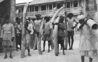 East Africans with elephant tusks to be used for ivory trade before the ivory trade became illegal.
In 1498, Vasco da Gama sailed around the southern tip of Africa. He landed in Mombasa. Da Gama was a Portuguese explorer. He wanted to trade with the local people, but he was forced to leave. He then sailed north to Malindi. The town of Malindi became the center of trade for Portugal. This was the beginning of the Portuguese empire in East Africa.
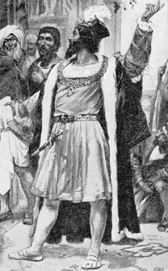 Vasco de Gama
Arab and Portuguese traders increased the slave trade. The main trading port for slaves was Mombasa. There was a good harbor where ships could land and be safe. Mombasa had plenty of flat land to build docks and warehouses. There was also deep water for large cargo ships. The port was sheltered from strong winds.
Arabs and Portuguese fought to control trade. In 1720, the Arabs drove the Portuguese out of East Africa.

Malindi is the oldest city on the east coast of Africa. In 1417, a Chinese explorer brought back a giraffe. The giraffe was a present from the ruler of Malindi to the Chinese emperor.
![]()
At first, Bantu people came to the region for the rich land and better climate. Arabs came to trade in ivory, gold, and slaves. The region had good harbors. Arabs and Bantu people created the Swahili language and culture. Portugal set up trading centers in the region, but the Arabs drove them out.
As you learned in the last chapter, Europe controlled most of the countries in Africa. In 1884, the colonial period began. Leaders in Europe divided the colonies in Africa. A colony is a territory or community that is under the control of another country. A government plan to set up colonies in parts of the world is called colonization. In 1885, Germany traded Kenya to England. The lands of Kenya and Uganda became known as British East Africa.
When you need to remember dates, make a time line that shows the sequence of events. Sequence, or time order, is the order in which events happen. In 1944, an organization called the Kenyan African Union (KAU) began. From 1952 until 1956, the Mau Mau fought white settlers.
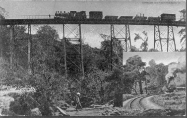
In 1895, the British government opened lands inside Kenya to white settlers. The settlers cleared forests in the highlands. They made huge tea plantations. The government built a railroad from the ocean port city of Mombasa to Kisimu on Lake Victoria. This opened the center of the country for trade. Nairobi became an important city along the train route.
In 1944, the Kikuyu (kih-koo-yoo) and some other tribes formed the Kenyan African Union (KAU). They wanted to find a legal way to change the laws that kept black Africans from voting. The KAU also wanted independence from Britain.
In 1947, Jomo Kenyatta became president of the KAU. His tribe, the Kikuyu, set up a secret group. This group was called Mau Mau. From 1952 until 1956, the Mau Mau fought white settlers. The British arrested Jomo Kenyatta. They believed he was a leader of the Mau Mau.
In 1963, Kenya became independent from Britain. Jomo Kenyatta was elected the first president.
 Train leading from Mombasa to Nairobi in 1910.
500 BC Bantu migration
AD700 Arabs begin trading in the region
1498 Vasco da Gama arrives-beginning of Portuguese empire
1720 Arabs drive Portugal out of East Africa
1830 Arab slave trade grows
1885 Germany trades East African coast to Britain
1895 British government opens lands to white settlers
1944 Kenyan African Union fights for independence
1952 Mau Mau fight British rule
1963 Independence from Britain-colonialism ends
Wind of Change. British Prime Minister Harold Macmillan gave an important speech about British colonialism in 1960. His words are known as the “wind of change” speech. He told people that the government wanted to change policies, or plans, in Africa. England was ready to give independence to African colonies. By the end of the 1960s, most British colonies became independent.
Primary Source
“The wind of change is blowing through this continent. Whether we like it or not, this growth of national consciousness is a political fact.”
Prime Minister Harold Macmillan
![]()
By 1885, England controlled Kenya. White settlers moved into the highlands and set up huge plantations. They opened up land in Kenya to white settlers. In 1944, the KAU was formed. They wanted independence from Britain. In 1963, Kenya gained its independence from Britain.
Wish You Were Here?
 The Great Rift Valley was formed when a block of land sank down between long faults, or cracks, in the earth
Additional topics
- Review
- How Has History Affected the People of Sub-Saharan Africa? - Who Are the People of Sub-Saharan Africa?
- Other Free Encyclopedias
History Reference: Ancient History & World HistoryThe Eastern Hemisphere - Africa