What Is the Geography of Africa?
What Is the Climate Like?

The Mediterranean Sea separates Africa from Europe. Africa is the second largest continent. It has almost 12 percent of the world's population. Africa's population is growing rapidly. However, most of the soil is poor for farming, and there is little fresh water. About a quarter of the land is desert. These deserts are spreading. Africa cannot grow enough food to feed its people.
Africa is a huge continent. It covers one-fifth of the earth's land. Africa is located south of Europe and Southwest Asia. Look at the map on page 119. Notice that the equator runs through the middle of the continent. Because of the location of the equator, most of Africa has a tropical climate.
There are not many mountain ranges in Africa. Mt. Kilimanjaro is the continent's highest mountain. Several large deserts separate parts of Africa, making trade and transportation difficult. The Sahara Desert separates North Africa from Southern Africa. It is the largest sand desert in the world. The area is hot and dry.
At one time, the Sahara was mild and wet. But long periods of little rainfall, called droughts, dried up the soil and damaged crops. Droughts destroy farmland. People cannot grow food. They cannot grow grasses to feed their animals. Winds blow the dry soil away.
Droughts cause desertification. Desertification means that the desert is spreading. More areas in West Africa and parts of the Sahel are now deserts. Because there is no food or water, people die or must move away.
Find an area on the map called the Sahel (sah-hel). The Sahel is a green belt of land. It separates the savanna from the desert. This area has dry grasslands with very little rain. The most fertile area in Africa is the Congo Basin. Rain forests in the Congo Basin receive over 60 inches (152 cm) of rain a year.
North and south of the rain forests are savannas. Savannas are grasslands with very few trees. Large grazing animals, such as elephants, lions, zebras, and giraffes, live on the savannas.
In East Africa, the Great Rift Valley is 3,000 miles long. A rift valley is a place where the earth's crust stretches until it breaks. This region has many lakes. Find Lake Victoria on the map. Lake Victoria is the source, or beginning, of the Nile River. The Nile River is the longest river in the world. It flows north through East Africa, Egypt, and into the Mediterranean Sea. The Nile is like a long oasis running through the desert. It brings water and fertile soil to the area.
Another important river is the Niger River in West Africa. It starts in mountains near the Atlantic Ocean. The Niger flows 2,600 miles and empties into the Gulf of Guinea.
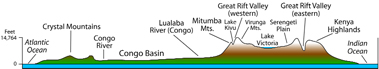 Cross section of the elevation in Africa south of the Sahara.
 Physical Map of Africa
![]()
Africa is the second largest continent. It is a continent with mostly a tropical climate. Large deserts separate areas of the continent. They make trade and travel difficult. Millions of people live along the edges of the deserts. The Nile and other rivers supply water for irrigation.
What Is the Climate Like?
Look at the climate map. Much of Africa has the same climate. The large areas in the north and south have desert climates. There is not much rainfall. Tropical climates are near the equator. In the Sahara Desert, most areas receive less than 5 inches of rain a year. Temperatures are extreme. They range from freezing to over 120° F. The highest temperature in the world was recorded in Libya in September 1922. It was 136° F.
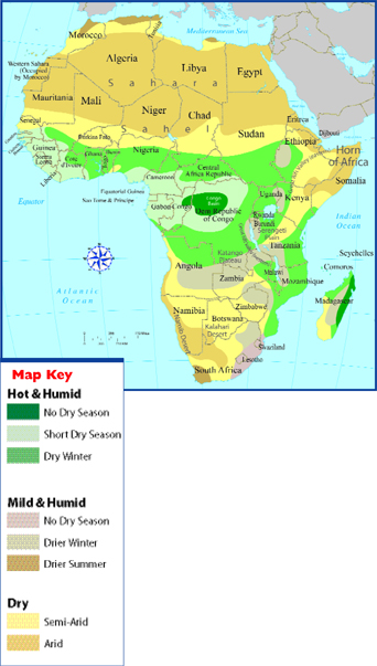 Climate Map of Africa
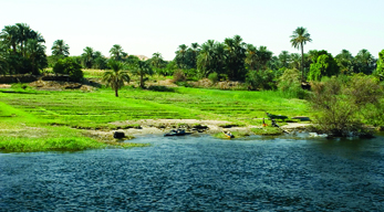 Farmland along the River Nile, Egypt
How Is the Land in Africa Used?
There is not enough water in Africa. Rivers are very important. Most of the farmland in Africa is along rivers. In Egypt, the Aswan Dam was built on the Nile River. This dam supplies water to millions of people. A dam on the Zambezi (zam-bee-zee) River in southern Africa supplies power for electricity. In West Africa, the Niger River carries goods and people throughout the region.
The land in southern Africa is rich in natural resources. There are gold, diamond, and iron ore mines. Large areas of copper mines stretch across Zambia.
Many African farmers practice slash and burn farming. This process is a way to clear land for planting by cutting and burning forests. This process of cutting down or burning all the trees in an area is called deforestation. Because the tree roots die, they can no longer hold the soil in place. Wind and rain carry the rich topsoil away.
Deforestation causes floods during the rainy season. On the island of Madagascar, slash and burn farming has destroyed 80 percent of the island's forests.
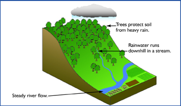 Forested Hillside
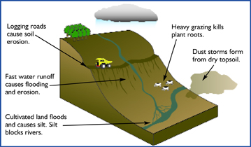 After Deforestation
The diagrams show how deforestation affects the tropical rain forests.

To understand an inference, you must “read between the lines,” or make a guess based on the facts and ideas you are given. To make an inference, use the information and details that you read, your prior knowledge, and your common sense.
![]()
Most of Africa has a tropical climate. There are also huge deserts. Tropical rain forests lie along the equator in the middle of the continent. The deserts, droughts, and deforestation make raising food and animals difficult for many countries in Africa.
Additional topics
- How Has History Affected the People of North Africa? - Who Are the People of North Africa?, What Is North Africa Like Today?
- What Is Africa Like?
- Other Free Encyclopedias
History Reference: Ancient History & World HistoryThe Eastern Hemisphere - Africa