Review
Directions: Use a pencil to fill in the circle that has the same letter as the answer you have chosen.
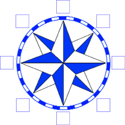
1. Fill in each box to complete the compass rose.
2. Which imaginary line divides the earth into the Northern and Southern Hemispheres?
Ⓐ prime meridian Ⓑ equator
Ⓒ scale Ⓓ South Pole
3. The main purpose of a physical map is to show
Ⓐ population density. Ⓑ climate.
Ⓒ mountains and rivers. Ⓓ countries and borders.
4. Polar, dry, mild, and tropical can be described as
Ⓐ climate zones. Ⓑ plants.
Ⓒ temperatures. Ⓓ physical features.
5. The purpose of a map key, or legend, is to
Ⓐ measure distance. Ⓑ show direction.
Ⓒ show elevation. Ⓓ explain symbols.
Base your answers for 6 and 7 on the circle graph (left).
6. In 2001, what country or region had the least carbon pollution in the world?
Ⓐ United States Ⓑ China
Ⓒ Japan Ⓓ Russia and Eastern Europe
7. Which two countries or regions together have the most carbon pollution in the world?
Ⓐ United States and China
Ⓑ Japan and China
Ⓒ Western Europe and the United States
Ⓓ Russia and Eastern Europe and Western Europe
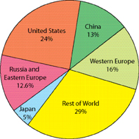 2001 World Carbon Pollution
Base your answers to question 8 on the two maps below.
8. Based on these two maps, why do you think Japan has to import most of its food to feed the people?
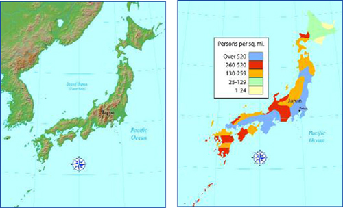 Physical Map of Japan
Population Density of Japan
Additional topics
- What Are the Different Types of Maps and Graphs? - What Are Physical Maps?, What Are Political Maps?, What Are Special Purpose Maps?
- Other Free Encyclopedias
History Reference: Ancient History & World HistoryThe Eastern Hemisphere - Geography, Globes, Maps and Graphs