How Do I Use Globes and Maps?
Globes, How Do I Read Latitude and Longitude?, Maps, What Are the Parts of a Map?

Do you know how to find the library in your town? Can you locate the fire station or the grocery store? Globes and maps help you locate places. Learning how to use globes and maps gives you a better understanding of the world.
Globes
A globe is a round ball like the earth. A ball is the best way to show the earth because it has the same shape. Globes have a grid of imaginary lines. These lines help you find places on the globe.
One imaginary line is called the equator. It is halfway between the North and South Poles. The equator divides the earth into two halves called hemispheres. Everything north of the equator is in the Northern Hemisphere. Everything south of the equator is in the Southern Hemisphere.
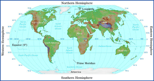 People in Europe live in the Northern Hemisphere. People in Australia live in the Southern Hemisphere.
Another imaginary line on the globe is the prime meridian. This line runs from the North Pole to the South Pole. It divides the earth in half from top to bottom. The prime meridian runs through Greenwich, England. The Eastern Hemisphere is the area from the prime meridian east to 180° of longitude. The Western Hemisphere is the area from the prime meridian west to 180° of longitude.
How Do I Read Latitude and Longitude?
Other imaginary lines on globes and maps are called latitude and longitude. These lines crisscross and look like a grid. The lines are measured in units called degrees (°).
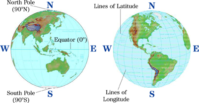
Lines of latitude, or parallels, are east-west circles around the globe. The main line of latitude is the equator. It is located at zero degrees latitude (0°). Latitude lines measure distances north or south of the equator. The farthest latitude north of the Equator is the North Pole, 90° north. The farthest latitude south of the Equator is the South Pole, 90° south.
Lines of longitude, or meridians, run north and south. The prime meridian is the important line of longitude. It is located at zero degrees longitude (0°). Half of the lines of longitude are west of the prime meridian, and half are east of it. Longitude lines measure distances east and west. The maximum longitude is 180°. That is halfway around the earth from the prime meridian. The place where a line of latitude crosses a line of longitude is called the absolute location.

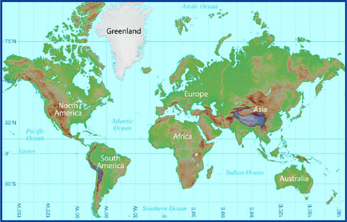
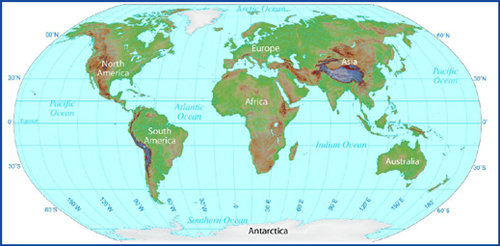
Is there a place on the earth with no latitude and longitude? Look on the map on page 10 for 0°N-S and 0°E-W. It's a point in the Atlantic Ocean, off the west coast of Africa. This is where the prime meridian and the equator meet.
![]()
The imaginary lines on globes and maps help locate any place on the earth. Lines of latitude circle the earth. Latitude describes how far north or south from the equator a place is. Lines of longitude run through the poles. Longitude describes how far east or west a place is located from the prime meridian.

Globes are a great way to see what the earth looks like. But they are difficult to carry around. They cannot show you details of your city or your state. As people explored where they lived or traveled, they recorded information. They noted islands, mountains, and bodies of water. People used this information and made flat maps. One of the earliest “flat” maps was made in Babylon. This ancient city was near Baghdad in Iraq. The map was carved into clay.
Maps
A map is a flat drawing of all or part of the earth's surface. It shows where places and things are located. Maps also show how things are connected to each other. They show size, distance, and direction. Some maps include physical features. They show lakes, mountains, and rivers. Other maps show where people live. These maps might show political features, such as cities and country boundaries.
What Are the Parts of a Map?
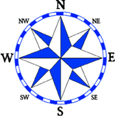
To read a map, first look at the title. The title explains the subject of the map. Maps also have a compass. This symbol is called a compass rose. It tells the cardinal directions of north (N), south (S), east (E), and west (W). The compass rose also has four intermediate directions. These are called ordinal directions. They are northeast (NE), northwest (NW), southeast (SE), and southwest (SW).
The directions of a compass tell you where places are located. Look at the Treasure Map. You can see that the Camelback Mountain Range is located south (S) of Hastings Cove. But it is also located west (W) of the cove. To describe its location, you can say that the Camelback Mountain Range is southwest of Hastings Cove.
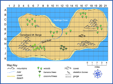 Treasure Map
Cartographers (kar-tog-ruh-fuhrs), or mapmakers, also use symbols to show locations and features. These symbols can be lines, dots, patterns, or pictures. A map key, or legend, explains what the map symbols stand for. Symbols change from map to map. On one map, a red dot means a small city. On another map, the red dot can mean the location of a train station. To understand a map, always study the title and the map key.
A map scale measures distances on a map. It is a line marked in miles, kilometers, or both. It shows how distance on a map compares to real distance. Maps often show lines of latitude and longitude. Use a ruler to measure the distance between two points on a map. Then add the number of miles from the map scale to find the total distance.
The Treasure Map shows a grid of numbers and letters to help you judge distance on the map. Each square on the Treasure Map is equal to one mile.
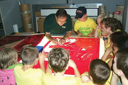 A group of children watch a cartographer at work.
![]()
Maps show the location of places and features on the earth's surface. A title, compass rose, map key, and scale are important tools mapmakers use to help you read a map.
What Are Map Projections?
The most accurate way to show the earth is as a globe. It is very difficult to draw a round object on a flat surface. A map projection is a way of drawing a picture of a round earth onto a flat map. These maps change the shape of some features on the earth. Each map projection is different. There is no correct projection. Mapmakers create projections with features that are important to them.
Mercator Projection A Mercator (muhr-kayt-uhr) projection map is useful for ocean navigation. The compass directions are correct. However, the lines of latitude and longitude are straight lines instead of curved. These lines are curved on a globe.
Some areas on the map are also not correct. The North Pole and South Pole regions look larger than they really are. This type of map shows correct direction and land shapes, but not distances or sizes.
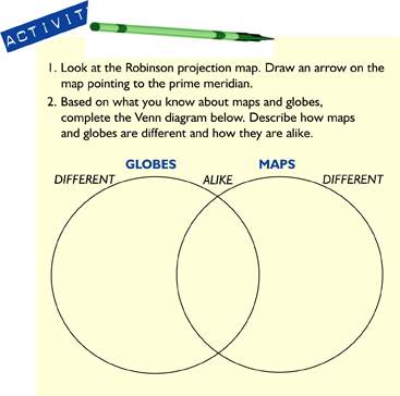
Robinson Projection This map shows the earth with a flat top and bottom. The lines of latitude are straight lines. The lines of longitude are curved lines. In a Robinson projection map, the areas look correct. But the distances and compass directions are not correct. Areas near the North and South Poles appear flattened.
Winkel Tripel Projection This map uses curved lines to show latitude and longitude. Study the shapes of the North and South Pole regions. They are more accurate than they are in the Robinson Projection. Recently, the National Geographic Society began to use this kind of projection map. They use it for all of their maps of the world.
![]()
Map projections show the curved surface of the earth on a flat map. As a result, the size, shape, and direction of some parts of the earth are not correct.
Additional topics
- What Are the Different Types of Maps and Graphs? - What Are Physical Maps?, What Are Political Maps?, What Are Special Purpose Maps?
- How Do the Five Themes of Geography Connect the World?
- Other Free Encyclopedias
History Reference: Ancient History & World HistoryThe Eastern Hemisphere - Geography, Globes, Maps and Graphs