What Is the Geography of Australia and the Pacific Region?
What Is the Climate Like?, How Is the Land Used?

Think about where you live. Do you live in a small town or a large, busy city? How might your life be different if you lived far out on a farm or in the middle of a crowded city? Australia and the Pacific region are isolated. That means they are separate from most of the world. As you read, think about how this isolation, or separation, might have affected the people, plants, and animals in this region.
Australia is one of the largest countries in the world. Yet it is the smallest continent. It has unique landforms. It really has not changed very much in more than 250 million years. It is also the flattest continent.
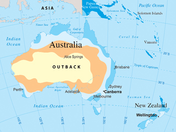
Notice the Great Dividing Range on the map. It runs along Australia's eastern coast. This low mountain range is the largest in the country. To the west, there are stretches of wide, flat, and dry land. This area is called the outback. Australia is very dry. Deserts cover one-third of the country. Most of the people live along the northern and eastern coast. This is where most of the fresh water is found. In contrast, New Zealand is mild and wet. It has green hills and mountains.
Look at the northeastern coast. There you'll find the Great Barrier Reef, the world's largest coral reef. A coral reef is a rocklike structure at or near the water's surface. It is formed by the skeletons of small sea animals.
The Pacific Islands are divided into three regions: Micronesia, meaning “tiny islands”; Melanesia, the most heavily populated Pacific Island region; and the largest region of Polynesia, meaning “many islands.”
The islands are classified as either high or low islands. Volcanic activity formed most of the high islands. They came to life when volcanic mountains grew from the ocean floor and reached the surface. Tahiti and Hawaii are high islands. Low islands, like Wake Island, are formed by coral. They are usually much smaller and lower than high islands. Wake Island is only 21 feet (6.4 m) above sea level.
Most low islands are atolls. An atoll is a horseshoe-shaped island formed by coral and surrounded by a lagoon. A lagoon is a shallow body of calm water. It is separated from the sea by a narrow strip of land.
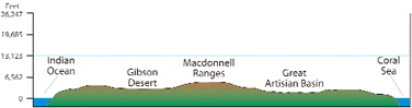 This Chart shows the different elevations of land areas across Australia. This cross section was taken at the Tropic of Capricorn at 23 1/2 ° S latitude.
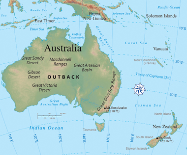 Physical Map of Australia and the Pacific Region

When you take notes, you write down the most important ideas and details from a paragraph, chapter, or passage. A chart (graphic organizer) or an outline can help organize information.
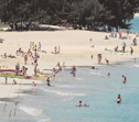 A high island: Kailua Beach, Hawaii
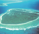 An atoll island

![]()
Australia is both a country and a continent. Its landscape has remained unchanged for about 250 million years. It is also the flattest continent. Most islands in the Pacific Region were formed by volcanic mountains (high islands) or atolls (low islands).
What Is the Climate Like?
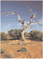 Dry outback landscape
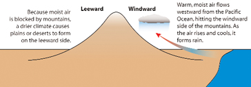
In most of Australia, the climate is warm. There is little rainfall. Most of the country has desert and steppe climates. A steppe climate is dry, but it does receive slightly more rain than a desert does. The exception is along the east coast. Here the farmland is fertile and there is plenty of rain. Winds flowing westward from the Pacific Ocean rise to go over the mountains. As the winds rise, moisture drops as rain. Since the climate is mild and pleasant, most Australians live along the coast. In contrast, New Zealand has a mild climate with a lot of rainfall.
Most of the islands are tropical. The climate is humid, and rain falls all year. Because New Guinea has high mountains, the climate is cooler.
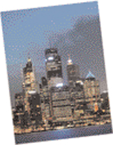 Sydney skyline
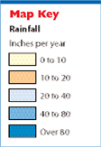
 Rainfall Map of Australia
How Is the Land Used?
Australia is rich in resources. It is the world's top producer of bauxite (used to make aluminum) and lead. It also has diamonds and opals. Energy sources include natural gas, oil, and coal. Even though Australia has poor soil, people still grow wheat and cotton and raise sheep. In fact, the country exports 86 percent of its wheat. Compare the Rainfall and Land Use maps. You can see that commercial farming occurs where there is plenty of rainfall. New Zealand has fertile farmland but few mineral resources.
 Land Use Map of Australia
The low islands have thin soil and few trees and plants. Because of this, their populations are small. The high islands have many natural resources. Volcanic soil makes rich farmland and thick forests. People grow coffee, bananas, cocoa, and sugarcane.

When you draw a conclusion, you make a decision based on the facts you are given. Facts that give information about a subject are called evidence. First, look for all the facts given. Use these to help you draw a conclusion. Make sure the facts (evidence) support your conclusion.
Evidence: The east coast of Australia gets plenty of rain, but the central area gets little rain.
Conclusion: The east coast is better for farming than central Australia.
![]()
Australia's climate and land use is different from I the climate and land use in New Zealand and the islands. Most of Australia is dry. The east coast gets the most rain. The islands are mostly tropical. Low islands have few mineral resources. High islands have fertile soil and more natural resources.
Additional topics
- How Has History Affected the People of Australia and the Pacific Region? - Who Are the People of Australia and the Pacific Region?
- What Is Australia and the Pacific Region Like?
- Other Free Encyclopedias
History Reference: Ancient History & World HistoryThe Eastern Hemisphere - Australia and the Pacific Region